The first instalment of a four part NY Times series, The Outlaw Ocean, by Ian Urbina was published yesterday. The  first instalment, Stowaways and Crimes Aboard a Scofflaw Ship, follows the activities of one particular ship, including an incident where two stowaways were forced overboard and left adrift on a makeshift raft while the ship was at sea off West Africa. From the NYT: “The Outlaw Ocean series was a deep collaboration, with many parts of the newsroom working with Ian Urbina on a quest to reveal lawlessness on the high seas. The hope for the project was to take readers inside that lawlessness, using video, photography, mapping and design tied closely together.”
Category Archives: Maps
NY Times: The Outlaw Ocean Series – Stowaways and Crimes Aboard a Scofflaw Ship

European Migrant Death Database – Deaths at the Borders of Southern Europe
VU University Amsterdam has released a border death database documenting migrant deaths along the Southern European borders.
Here is a web post from DIIS (Danish Institute for International Studies) describing the project: “On 12 May 2015, researchers of VU University Amsterdam  released a border death database, based on official death records of migrants who died at the Southern European borders in the years 1990-2013. They suggest that European states continue to collect such data supervised by a new European Migrant Death Observatory which is should be part of the Council of Europe.
The database contains individualized information on 3.188 people who died while attempting to reach southern EU countries from the Balkans, the Middle East, and North & West Africa, and whose bodies were found in or brought to Europe. It is unique because it includes – where known – date and place of death, cause of death, gender, age, country of origin, and whether or not the person was identified. Over the past year, 13 researchers visited 563 local civil registries in Spain, Italy, Greece, Malta and Gibraltar and collected information from death certificates. “This database underlines decades of indifference of European states. They had this information all the time, but failed to collect it”, says Professor Thomas Spijkerboer.
The database can be accessed through www.borderdeaths.org
It includes:
o Full database
o Visualization
o Documentary Counting. The Human Costs of Border Control (Pieter Boeles, 2014) about the research project
o Papers on (1) how was the data collected; (2) preliminary findings; (3) identification; (4) policy relevance”
See also: The short documentary Counting the Human Cost of Border Control, in which Thomas Spijkerboer and Tamara Last (Migration Law, VU University Amsterdam) search for traces of those who have died in the civil registries along the Mediterranean coast.
Share this:

Filed under Analysis, Data / Stats, European Union, Maps
German Shipowners’ Association (VDR) Criticises Growing Reliance on Merchant Vessels to Conduct Mediterranean Sea Rescue – Calls for Expansion of SAR Boundaries
Ralf Nagel, the Chief Executive Officer of the German Shipowners’ Association (VDR), last week called on Germany to deploy Navy vessels outside of the Frontex Triton operation zone and closer to the coast of Libya where private merchant ships are often the first to encounter migrant boats in distress. At least two German Navy ships were in Crete last week waiting for deployment instructions. “Deploying the [German] Navy in that part of the Mediterranean would not only send a strong political signal to Brussels, it would also be an important message for the shipping industry, which is doing all it can. And above all else: it would save the lives of innumerable refugees. Rescuing people at sea ought to be the responsibility of navy and coast guard vessels as a rule. … [W]e therefore demand that the boundaries within which maritime rescues are conducted by government forces be expanded beyond the Triton zone.”
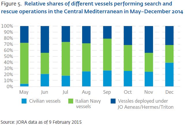
According to the Frontex Annual Risk Analysis 2015, private merchant ships have been conducting an ever increasing number of search and rescue operations in the Mediterranean. In December 2014, merchant vessels accounted for just under 40% of the SAR operations. (See graph below map.)
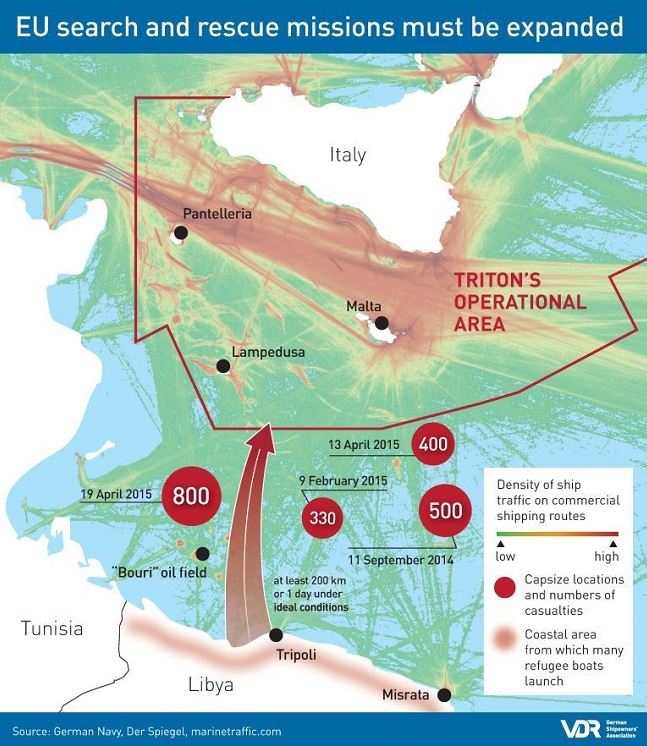
Source: Verband Deutscher Reeder (VDR) / German Shipowners’ Association (VDR)
Share this:

Filed under European Union, Frontex, Germany, Libya, Maps, Mediterranean, News, Statements
Libya Group With Control Over Tripoli and Libya’s Western Coast Says It Will “Confront” Unilateral EU Attacks on People Smuggler Sites
Libya Dawn, “[t]he group controlling Libya’s coastal capital Tripoli [and the Mediterranean coastal areas to the east and west of Tripoli] says it will ‘confront’ any unilateral European Union moves to attack sites used by people smugglers, urging the [EU] to consult it over plans to deal with the migration crisis.” (Click here for Guardian article-reporting based on Times of Malta interview with the group’s foreign minister.)
The political and security situation in Libya is complicated. And while migrant boats tend to depart from areas around Tripoli because the area is closer to Lampedusa and Malta, boats leave from eastern areas of Libya as well. If the EU does end up taking military action in Libya, it will necessarily engage with different militias and political groups.
Libya Situation Map mid-April 2015 – Map by @arabthomness.

Share this:

Filed under European Union, Italy, Libya, Malta, Maps, Mediterranean, News
Map: “Africa without its margins” (Le Monde Diplo/Philippe Rekacewicz)

“Africa without its margins,” Le Monde Diplomatique, by Philippe Rekacewicz, Nov. 2012.


